Geospatial Analysis for Mapping and Monitoring Crop Health Trends: A Key Component in Shaping the Crop Outlook

In the ever-evolving landscape of modern agriculture, the integration of geospatial analysis has emerged as a powerful tool for mapping and monitoring crop health trends. The ability to collect and analyze geographic information provides invaluable insights into the spatial distribution of crops, helping farmers, researchers, and policymakers make informed decisions. This article explores the significance of geospatial analysis in monitoring crop health monitoring trends and its direct impact on shaping the crop outlook.
Contents
Geospatial Analysis: An Overview:
Geospatial analysis involves the examination of geographic data to uncover patterns, trends, and relationships. In agriculture, this technique is increasingly applied to monitor and map crop health. With advancements in satellite technology, unmanned aerial vehicles (UAVs), and ground-based sensors, geospatial analysis has become an essential component of precision agriculture.
Mapping Crop Health:
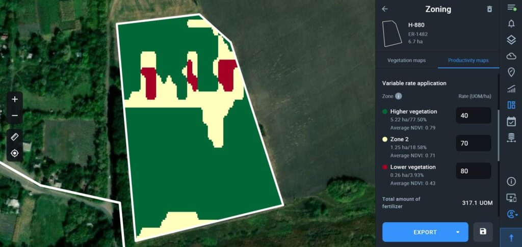
One of the primary applications of geospatial analysis in agriculture is the mapping of crop health. Satellite imagery, with its ability to capture detailed information over large areas, provides a bird’s-eye view of crop conditions. By analyzing spectral signatures, researchers can identify variations in vegetation health, detect stress factors, and pinpoint areas of concern.
Geospatial mapping allows for the creation of thematic maps that showcase the spatial distribution of crops and their health status. These maps are instrumental in identifying regions facing challenges such as nutrient deficiencies, water stress, or the presence of pests and diseases. Farmers can then use this information to implement targeted interventions, optimizing resource use and minimizing environmental impact.
Monitoring Crop Health Trends:
Geospatial analysis goes beyond static mapping and enables the dynamic monitoring of crop health trends over time. Time-series analysis of satellite imagery provides a temporal dimension to crop monitoring. By comparing images taken at different points in the growing season or across multiple years, researchers can track changes in crop health, assess the effectiveness of interventions, and identify long-term trends.
This temporal analysis is particularly valuable for understanding the impact of external factors such as climate variability on crop health. By correlating geospatial data with meteorological information, researchers can unravel the complex relationships between environmental conditions and crop performance, contributing to more accurate crop health predictions.
Integration with Crop Outlook:
The crop outlook, a projection of anticipated production and market conditions, is intricately connected to the monitoring of crop health trends through geospatial analysis. Accurate and timely information on crop health directly influences the crop outlook, providing stakeholders with crucial data for decision-making.
For instance, if geospatial analysis indicates a widespread occurrence of pests in a particular region, this information can be integrated into the crop outlook to anticipate potential yield losses. Similarly, insights into variations in crop health due to climatic factors can be factored into market predictions, influencing commodity prices and trade dynamics.
Precision Agriculture and Resource Optimization:
Geospatial analysis plays a pivotal role in precision agriculture, where the emphasis is on optimizing resource use while maximizing productivity. By precisely mapping and monitoring crop health, farmers can tailor their agricultural practices to specific field conditions. This includes targeted irrigation, customized fertilization plans, and the timely application of pesticides.
The integration of geospatial data into precision agriculture not only enhances the efficiency of farming practices but also contributes to sustainable agriculture. Farmers can minimize the environmental impact by avoiding overuse of resources, reducing the risk of soil degradation and water contamination. This, in turn, positively influences the long-term crop outlook by fostering resilient and sustainable farming systems.
Challenges and Future Directions:
While geospatial analysis holds tremendous potential in monitoring crop health trends, challenges persist. Access to high-quality satellite imagery, the need for sophisticated analytical tools, and issues related to data privacy and security are among the hurdles that need to be addressed. Additionally, ensuring that the benefits of geospatial analysis reach smallholder farmers in developing regions remains a priority.
Looking ahead, ongoing advancements in satellite technology, machine learning algorithms, and the integration of ground-based sensors will further enhance the capabilities of geospatial analysis. Collaborative efforts between governments, research institutions, and technology providers are essential to overcoming challenges and ensuring the widespread adoption of geospatial techniques in agriculture.
Conclusion:
Geospatial analysis has emerged as a game-changer in the realm of agriculture, offering a comprehensive view of crop health trends. By mapping and monitoring crops with precision, stakeholders gain valuable insights that directly influence the crop outlook. The integration of geospatial analysis into agriculture practices not only enhances resource optimization and productivity but also contributes to the sustainability of global food production.
As technology continues to advance, geospatial analysis will play an increasingly vital role in shaping the future of agriculture. By leveraging this powerful tool, stakeholders can navigate the complexities of modern farming, adapt to changing environmental conditions, and contribute to a more resilient and sustainable crop outlook.